On this page: South Ronaldsay | Burray | Other chapels and gospel halls [The opening picture is of St Peter’s Church, Kirkhouse]
We have used the terms Common Era (CE) and Before the Common Era (BCE). They cover the same periods as Anno Domini (AD) and Before Christ (BC).
South Ronaldsay
There are a significant number of old chapels and churches dotted about the islands. Some are in ruins, others have been converted to housing and various other uses, and several are now just memories. When exploring Burray and South Ronaldsay, it is worth bearing several things in mind.
First, up to the Reformation, which is usually marked by the publication of Martin Luther’s Ninety-five Theses in 1517 CE, Christianity had been an important presence in many Western European countries for a thousand years or more. The first Roman emperor to convert to Christianity was Constantine the Great (in 312 CE). In 381 CE, Nicene Christianity was named as the official religion of the Roman Empire and was often described as the Roman Church and the Catholic Church.
Second, at the time of the Reformation, engagement with Christianity was closer to 500 years for many inhabitants in what might be described as Viking or Norse Scandinavia (Peter Marshall 2024: 85). In Orkney’s case, this period could be as long as 750 years. As we discuss below, Cormac Ua Liatháin arrived in South Ronaldsay around 580 CE, and the Viking invasion of Orkney took place around 800 CE. However, it and Shetland were not officially annexed by the King of Norway until 875 CE.
The arrival of the Vikings and Norse inhabitants appears initially to have led to a significant decline in Christian worship. However, there is evidence of a revival of Christianity in Orkney during the 11th and or 12th centuries [see the History of Catholicism in Orkney]. An obvious demonstration of change was the founding of St Magnus Cathedral in 1137 by Earl Rögnvald of Orkney and Shetland. St Magnus (Erlendsson) had been the earl of Orkney and was known for his piety. Executed in the island of Egilsay on the order of his brother (Haakon Paulsson), he was initially buried in Birsay (then the diocesan headquarters). His bones were then transferred to a shrine in the cathedral and some churches in Europe. Earl Rögnvald, who was St Magnus’s nephew, was appointed by King Sigurd I of Norway in 1129. He went on to undertake a pilgrimage to the Holy Land and was canonised in 1192 by Pope Celestine III. South Ronaldsay and North Ronaldsay were named after him.
Third, St Magnus Cathedral in Kirkwall was both a beautiful addition to and enhancement of the town’s importance. However, it cost a lot to maintain and run. From at least the fourteenth century, parish funds were increasingly diverted to it, with the result that local parish ministry and buildings suffered. As Peter Marshall (2024: 82) has commented, ‘the Church was left in a poor shape to weather the coming storm of the Reformation’ and what followed.
Fourth, from around 1440, the three main churches on Burray and South Ronaldsay were linked. St. Peter’s church in the north/Eastside of South Ronaldsay was united to the church of Our Lady (St Mary’s in the south) and to St Lawrence Kirk (aka St. Laurence) in Burray. Following the Reformation, they were no longer Catholic. The Church of Scotland, born during the Scottish Reformation of 1560, broke with Catholicism and, under the influence of John Knox and others, developed as a Protestant institution.
South Ronaldsay was then divided by the established church into two unequally sized parishes for much of the twentieth century. St Mary’s in the south was about half the size of St Peter’s in Eastside. South Ronaldsay also had several smaller chapels (nine in 1647) and later a couple of mission halls and a free church.
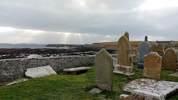
Old St Mary’s Church aka Lady Kirk in Burwick, South Ronaldsay (KW17 2RN, click for map. The kirk was probably established at this spot in the 11th century, however, the first record of it on a map dates from 1654. Before the opening of the Lady Kirk, there was a chapel (St Colm’s) a few hundred metres to the east dating from the ninth century or earlier (see below).
 Today, the church is no longer used as a parish church. That role is played by St Margaret’s Kirk in St Margaret’s Hope (see below). However, the building has been adopted by a group of local people who recognised its continuing significance historically and as a resource for the community. [Click to read a BBC report on the establishment oḟ the charity to buy and run the building]. The Kirk is also a category B listed building.
When open/how to gain access.. to be updated
The graveyard is accessible from the car park on the main road via a short, but rising, grassed path. The gates look to be wide enough for wheelchairs. It is a short distance to the Church door (which we need to check for width).
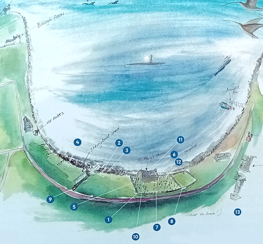
Here, it is worth mentioning five elements that make it one of the most interesting places to visit in Orkney (and it is free!).
First, Burwick’s coast is said to be where the earliest Christian missionaries landed in the Isles. Adomnan, the ninth abbot of Iona and the writer of Life of Columba (Vita Columbae), reports that Cormac Ua Liatháin arrived around 580 CE. He had probably sailed around the mainland from Iona, where St Columba’s monastery was based. It is said that Columba had met with King Brude, the Pictish chief ruler of the Orkney Islands, and asked that Cormac and others be protected. Cormac was later made an Irish Saint.
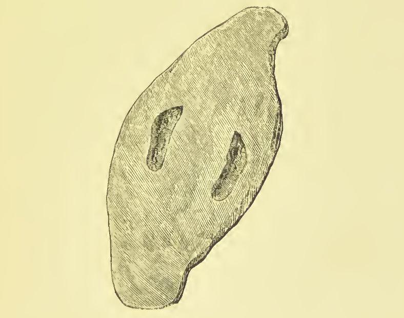
Second, Old St Mary’s is home to Ladykirk Stone. This is a rounded grey whin stone carved with two footprints. It was kept outside the church for many years but is now stored inside. There is some suggestion that it might be a Pictish coronation stone; however, it is associated with various other stories. The following dates from Joseph Ben’s Description of the Orkney Islands, published in Latin in 1529.
South Ronaldsay, another island, where the men are very strong. It has a temple near the sea shore, in which is a very hard stone, commonly called a Grey Whin, six feet long and four broad, in which is the mark of two naked feet, that no workman could have carved. The old people say, that a Frenchman having been banished from his country, embarked on board a ship as an asylum; but a violent storm arising, the vessel was wrecked; he however, leaping on the back of a sea-monster, stood there humbly praying to God, and vowing that if he was carried safe to land he would build a church in memory of his preservation, dedicated to the Virgin Mary. His prayer was heard, and he came safe to shore. The monster by whose assistance he was preserved, was afterwards changed into a stone, and placed by the Frenchman in the church, where it still remains, as I have already said.
At one point, the stone was called St.Magnus Boat (see The Megalithic Portal for more information). This is how George Low (1879) described it:
In Lady Kirk at Burwick saw a large stone which tradition says St. Magnus used as a boat to feiry him over the Pightland Firth, and for its service laid it up in this Church, where it is still preserved. Its shape is boat-like, but that it ever served that purpose is of the complexion of many-other Monkish stoiies which in times past were greedily swallowed by the unthinking vulgar. This stone is about 4 feet long, and 2 broad, about 8 inches thick, seems to have been taken from the next sea beach where many such are still to be found; has engraved on it the prints of a man’s feet, which probably furnished the first hint for the miraculous use of it, and may point out the true one, which there is little doubt but it was a stone appropriated to expose delinquents at the Church in times of Popery. George Low (1879) A Tour through the Islands of Orkney and Shetland
Third, like nearly all churches and chapels in South Ronaldsay, it is situated next to the sea, but unique in that it faces the Pentland Firth. As a result, visitors look across to John O’Groats and mainland Scotland, and at the Firth itself. Known for the strength of its tidal currents, which are among the fastest in the world, it also has a range of marine wildlife on view. Its name is said to be a development of the Old Norse ‘Petlandsfjörð’, which can be translated as ‘the fjord of Pictland’.
Fourth, it offers a fascinating short circular walk created by Sheena Graham-George and local residents. It takes in 13 different listening points that come alive on your mobile phone. Subjects include the Lady Stone, creels, coastguard, sheep, smallpox, the Sunday School, and the Island of Swona, which can be seen across the Firth.
If you want to take the walk now, just click for our online version.
Fifth, Old St Mary’s will become the home of a large and fascinating tapestry/quilt. It will show all the fields (and their local names) in the bottom half of South Ronaldsay. Currently, the tapestry is being worked on by local islanders (The Field Quilt Group) and will hang in the church once it is completed.
St Colm’s Chapel – just a mound now
Sant Colmis / St Colm’s Chapel, at Loch of Burwick, South Ronaldsay (KW17 2RN, click for map). There were a couple of other St Colm’s chapels in South Ronaldsay (in Hoxa and Grimness). The popularity of the name derives from the fact that it is a Gaelic variation on Columba. The work of St Columba (c. 521-597 CE) and his disciples was central to the conversion to Christianity of many living in Scotland during the sixth century. Columba was the Latin name for dove, and his Irish name Colm Cille, means ‘dove of the church’. There was a loch beyond the chapel, which has now been drained.
South Ronaldsay South Free Church and Manse – later St Mary’s Church of Scotland
Formerly St Mary’s Church of Scotland, Barswick, South Ronaldsay, Orkney Islands – originally South Ronaldshay South Free Church, Barswick, South Ronaldsay (KW17 2RN. Click for map). The church building was built in 1873 and officially opened in 1875. Before that, the congregation met across the road in Tomison’s Academy (from about 1870). The building to the left of the church was the manse (built in 1878). In 1900, the church was renamed the South United Free Church (after the coming together of the Free and United Presbyterian churches). In 1929, it became South Church (when the Presbyterians united with the Church of Scotland), and a couple of years later it united with St Mary’s Church (but stayed in use). We can see a similar pattern of change in Burray.
The church was closed and sold after the three Church of Scotland churches in South Ronaldsay were united in 1959. It became a house and – subsequently – a holiday home (Eastward House). The Manse was also sold (now known as Tanglin).
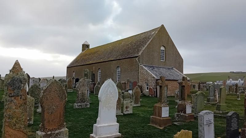
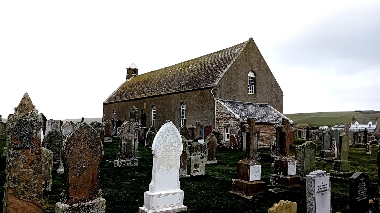
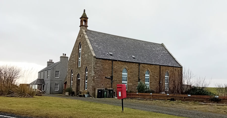
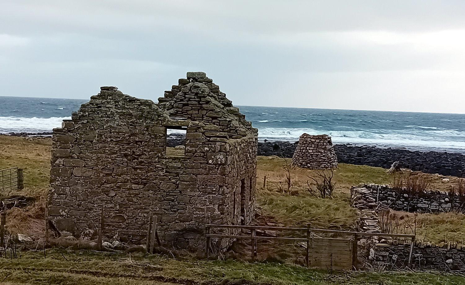
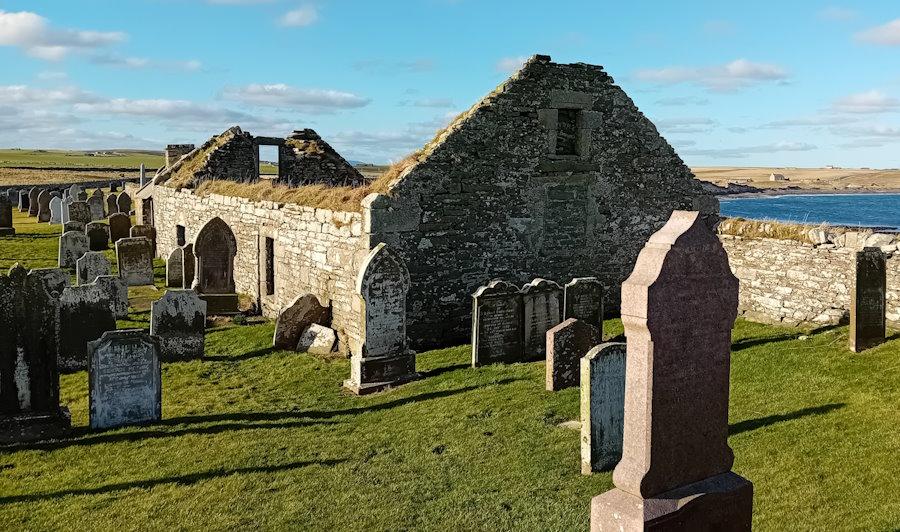
St Peter’s Kirk and graveyard aka North Kirk, Kirkhouse Road, South Ronaldsay (KW17 2TJ, click for map). The Kirk is normally open for viewing from 11 am to 3 pm (Thursday to Sunday over the summer). There are also guided regular tours of the Kirk and graveyard when it is open.
Like St Mary’s (above), St Peter’s is no longer used as a parish church – it was the North Parish Church (and graveyard) for this part of the island. Also, like St Mary’s, it is a listed building – in this case, a Category A one. The church was built in the 17th century (there is a date stone of 1642 over the door) and renovated in 1801 (and in 1967). It was likely built on the site of an older Eastside church. Like several churches in Orkney, it has a simple rectangular shape surrounded by a graveyard. It also follows St Mary’s with windows facing the sea and plain stone facing the land. The porch appears to have been added in the nineteenth century. The church hall (now a private property) was a mile (1.7k) away on the road to and from St Margaret’s Hope (click for map).
There are several things to note about the church and its surroundings.
First, the inside of the church is a bit of a treat. As British Listed Buildings notes:
The early 19th century interior is a rare survival and is remarkably complete. The communion tables running lengthwise down the centre of the church and the central box pew for the church elders are particularly worthy of note, and very few examples of either of these features now survive in Scottish churches.
This design means there is a pulpit with a sounding board on the long wall and a central communion table that stretches some distance. British Listed Buildings also records that the pews are thought to be made from driftwood. In 2006 it was upgraded from category B to A. This puts it in the same group as the Italian Chapel and St Magnus Cathedral. Category A buildings are ‘of national or international importance, either architectural or historic, or fine little-altered examples of some particular period, style or building type’.
Second, the church used to have, as part of its fabric, a Pictish symbol stone. It had been used to form the sill of a window. Trimmed slightly, it was 1.52m long and 48cm wide and is sculptured on both sides. It is now in the National Museum of Antiquities of Scotland. [See Canmore for pictures etc.]
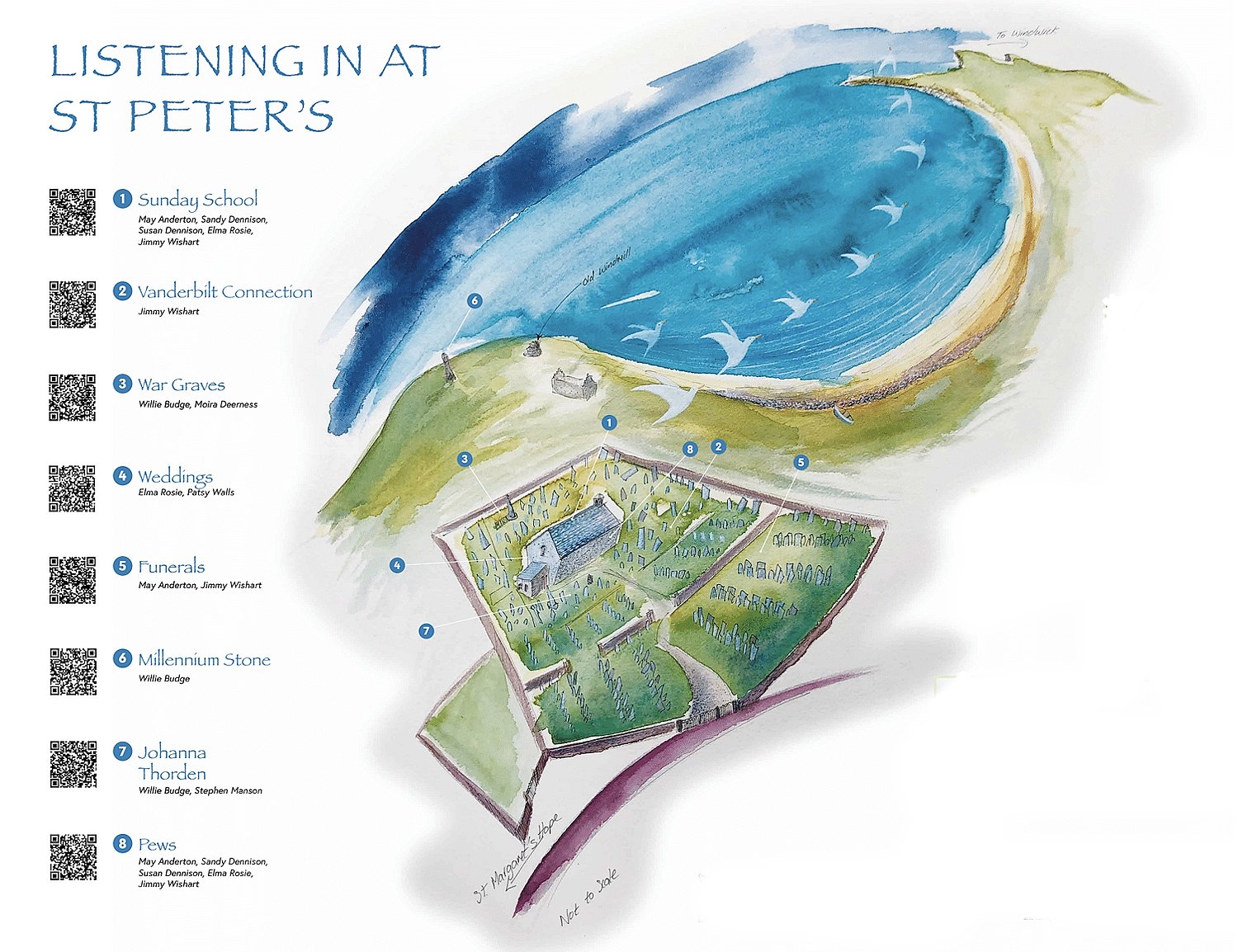
Third, just like St Mary’s, Burwick, there is a listening walk that features some fascinating stories about the kirk and the people buried in the graveyard. Created by Sheena Graham-George and local residents, it is not to be missed. Click to enjoy: Exploring St. Peter’s Kirk, [the listening walk].
Fourth, close by, there are several interesting buildings and things to see. These include:
A former fishing station just to the east of the graveyard.
The ruins of an 18th-century post mill, a few metres on.
Two fascinating Standing Stones. The first was created for the recent Millennium and is just around the corner from the windmill. The second is a little way up the road from the church. Click for details.
Kirk Ness Dyke and Kirk Ness Mound. These are a short walk north from the Millennium Stone. The dyke is within a planticrub – which is defined by Canmore as a ‘small square, circular or rectangular enclosure used for growing root crops, usually without an entrance’ (click for map). The mound is up behind the planticrub and is described in Canmore as an ‘amorphous, turf-covered, stony knoll… locally believed to cover an ancient structure.
If you carry on along the coast to the north, you can see what remains of the Irene – which sank on March 17, 1969. It had been on its way to Norway and was struggling to deal with the Force 10 gale. As a result, she ran out of fuel, had taken on a lot of water, and was drifting towards South Ronaldsay. She went aground here, and all of the crew of eleven were winched off the boat. However, one of the two lifeboats sent out to rescue them (the Longhope lifeboat) appears to have capsized with the loss of all eight crew members. The Irene gradually disintegrated, leaving her boilers, engine and various other elements.
Last, but not least, the North Sea laps close to your feet.
St Margaret’s Church/Kirk | South Ronaldsay & Burray Kirk, Church Road, St Margaret’s Hope (KW17 2SR – click for map).
This Kirk’s history connects with that of St Mary’s, Barswick and Burray United Succession Church. Now Church of Scotland, it was built in 1854-6 as a United Presbyterian Church and enlarged in 1870. The church then became South Ronaldsay United North United Free Church in 1900.
With the coming together of the United Free Church and the Church of Scotland in 1929, it became the South Ronaldsay St Margaret’s Church of Scotland. Later, it was designated as the central church for the Parish of South Ronaldsay and Burray. With the closure of the Burray Church of Scotland building, it gained the communion table and font from St Lawrence’s Church.
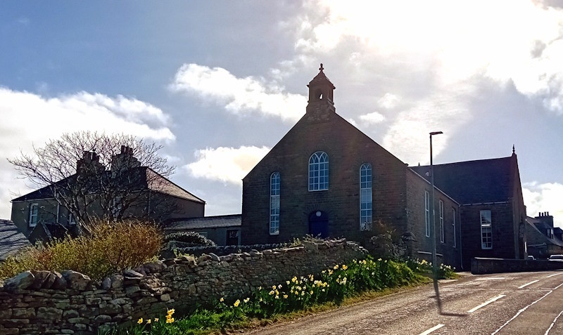
Major internal changes were made to the building in 2009. These involved reducing and enhancing the space devoted to worship and expanding the communal areas at the east end. The result was additional room for children, meetings, eating, and meet-ups. One of the areas, Ben End, has in recent years, been opened as a much-needed warm space for the local community.
The Manse and church office is located on the north side of the Kirk, and there is a substantial parking area to the east.
Sant Margrat in the Howp (St Margaret’s Chapel), School Road, St Margaret’s Hope, South Ronaldsay (KW17 2TN – click for map).
This area was excavated in the 1970s, and no evidence of the Medieval chapel thought to have been established on its site in the 13th Century was found. What the dig did reveal was evidence of foundations for an agricultural stone building dating from the mid-eighteenth century (Canmore). As we have seen elsewhere, this doesn’t mean that the Chapel was not here.
Burray
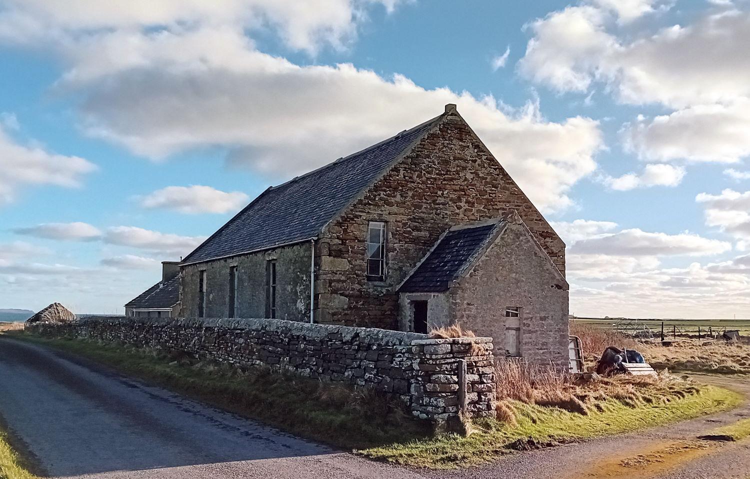
St Lawrence’s Church, Ness Road, Southtown, Burray (KW17 2TA click for map). Also known as Old Burray Kirk, St Lawrence’s looks out to Kirk Tang and Holm Sound. A path from the car park takes you along the coast to Bu Sand. Old Burray Kirk is a Category B listed building. The church appears to have been on this site since the 11th century and was probably a small private church linked to the Earldom estate at The Bu. In the 12th century, it looks to have been upgraded to a parish church (possibly in 1172, see Struthers 2013). It was rebuilt in 1621 by the then Laird, William Stewart of Mains and Burray. There were various problems with the building from around 1800. The roof was repaired in 1852; however, issues with the building continued. The last service was held in 1874. The Church of Scotland had decided to build a new church near Echna Brock (see below). Whilst the old parish church is roofless, it remains open to the public as a reflection space. Next to it is Burray’s war memorial, and it is surrounded on three sides by a burial ground. For more information, go to Canmore. There is an information board within the ruins.
St Lawrence’s Church II, Burray (KW17 2TA click for map). This building has now been replaced by an industrial shed. It was only in use for just over fifty years. Built to the same measurements as the old Burray Kirk, it used the old church’s roof. The Manse, however, remains and has been recently renovated. Now known as Summerton, it is next door on Bu Road. Towards the end of the nineteenth century, St Lawrence’s was separated from St Peter’s.

Burray United Succession Church / Burray United Presbyterian Church / United Free Church of Scotland / Church of Scotland, Water Road, Burray (KW17 2SS click for map). The United Succession Church existed until 1847 It then merged with the Presbytery of Relief to form the United Presbyterian Church, which in turn joined the United Free Church of Scotland in 1900. In 1929, it united with the Church of Scotland, and shortly, the two Burray congregations joined together. The building overlooking Echna Loch was vacated. The Manse was close by – just the other side of the Lawrona workshop and house.
Burray Baptist Chapel, Bu Road, Bu, Burray (KW17 2SZ – click for map). The Chapel was established by Alexander Kennedy. He had moved to Burray from Stroma (an island south of South Ronaldsay) in 1802 and set up a Baptist meeting for worship in his home. In 1840, the meeting moved from the house to the local public schoolroom. In 1848, they gained their own Chapel opposite the schoolhouse and, in 1862, a manse was built next door. With the decline of the fishing industry in Burray, attendance dropped. The Chapel closed in 1966.
Other chapels and gospel halls in South Ronaldsay
In addition to St Margaret’s Chapel in the Hope and St Colm’s Chapel by the Loch of Burwick, seven other chapels were recorded on the island in 1627. Sadly, there is also little to be seen at their sites – and for a number of them, this would have been the case back in the sixteenth century. Around 150 sites for chapels have been identified across the islands. As Peter Marshall (2024: 87) has pointed out, they were often ‘not more than a couple of dozen feet long’. Many appeared during the first century of ‘Norse Christianisation’. Most were close to the shore and often near burial grounds. Interestingly, they were often not far from Iron Age sites for habitation.
Sant Androis at Woundwick aka Saint Andrew’s Chapel, Windwick (KW17 2RN click for map). This is the site of the chapel and the burial ground, and is worth looking at if you are in Windwick for the Cairns etc. (Places not to miss 2)
Our Ladie at Halcro aka Our Lady’s Chapel and burial ground, Halcro Road (KW17 2RW click for map). The site of the Chapel is just off the road/track to Halcro. This is a turning on Holland Road, which takes you past Flaws Burial Ground. You should use the adjacent car park and walk up the track for about 400m. Ahead of you is Halcro Farm, which was the site of Halcro Castle (C13). The path to the site of the Chapel is on the left, but only enter the field if there are no cattle or rams. Again, there is not much to see (other than the view).
Ruid chappell in Sandwick aka Ruid Chapel and Burial Ground, Mucklehouse (click for map). The first thing to say here is to approach the area or return from it via Sandwick Road. Stop just after Cloudiehall and take the short path that takes you to Cist and the Standing Stone. If you are taking the South Ronaldsay West Coast walk from Sandwick Bay Road, there are various things to see, including two burnt mounds, Weems Castle and the site of Ruid Chapel (C14). The Chapel was behind Mucklehouse, but today, there is sadly little to see.
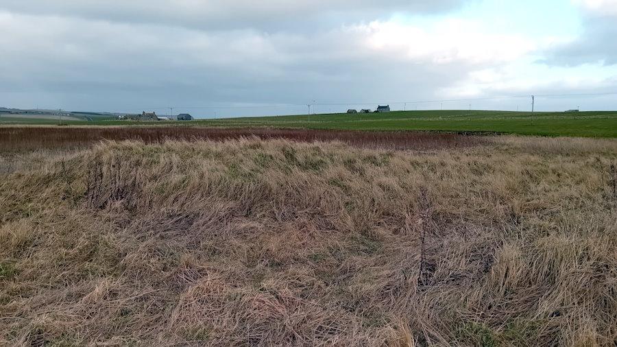
Sant Tola in Wydwall | St Ola’s Chapel and burial ground, Kirkhouse (KW17 2TG click for map). Take the track running alongside Widewall Bay – to the right of Kirkhouse Mill. Today, there is no sign of the Chapel, etc., which was thought to be from ‘Norse’ times. An excavation in 2006 revealed the remains of a substantial building, but no chapel was definitely located (Canmore).
Sant Colme in Hoxay | St Colms Chapel, Sands of Wright (KW17 2TW click for map). This 7th-century chapel is said to have been on the small knoll (known as Kirkie Brae) at the northwestern end of The Sands (Canmore).
Sant Colmeis in Grymnes | St Colm’s Chapel, Grimness (KW17 2TH click for map). No obvious remains of the 13th-century chapel can be seen, and, similarly, there is no trace of the burial ground (Canmore). We know that ‘the old chapel’ was there in 1660, as it is mentioned in the records of the South Ronaldsay Kirk Session. John Budge was named as someone who used the old chapel in times of heavy sickness, probably on the instruction of Katherine Manson, a local healer and suspected witch (National Records of Scotland SC10/1/5 48V; ‘Trials’ 167; Craven, Life 31). Six years later, the same Session sought to crack down on ‘charming and charmers, haunting of superstitious places as chapels or wells or other the like unlawful means of their health’ (Peter Marshall 2024: 215).
Sant Ninian in Stow. (Site of Saint Ninian’s Chapel, Stews – click for map). There are no obvious signs of the chapel and burial ground, other than a slightly raised, roughly rectangular area to the east of the Stews Standing Stone. Canmore describes it as a ‘Romish chapel … believed to have been established about the 14th century’.
There are also two gospel halls – one still active, and one now holiday accommodation.
Gospel Hall, Church Road, St Margaret’s Hope (KW17 2SR click for map). Gospel Halls started appearing in the late 1860s in Orkney. This hall is not shown on the 1879 Ordnance Survey map but is on the 1900 map. It is still in use – see Orkney Assemblies.

Mission Hall, Herston (KW17 2SR click for map). This hall has a crest on the north wall, dating it from 1884. As above, it is not shown on the 1879 Ordnance Survey map but is on the 1900 map. Picken (1972: 74) reports that at the time of building (in 1884), it was described as a ‘commodious, substantial and handsome place of worship’. It was opened on April 26, 1885. It looks out onto the Oyce of Herston and Widewall Bay – and has been converted for use as holiday accommodation.
If you find any mistakes in this piece or think something needs adding, please let us know.
All photographs without acknowledgement: mks | CC BY-NC-SA licence.
Further reading
Several books are well worth exploring:
Ben, Joseph (1529). Description of the Orkney Islands, written in Latin. Translation 1809. Republished in In: Belfast Monthly Magazine 2, no. 9. Ed. by William Drennan, pp. 266–271. It can be downloaded from CELT: Corpus of Electronic Texts: a project of University College, Cork [https://celt.ucc.ie/document/T800009-001/]. Retrieved January 4, 2026.
Foster, Sally M. (2014). Picts, Gaels and Scots. Early Scotland. Edinburgh: Birlinn.
McHardy, Stuart. (2011). A New History of the Picts. Edinburgh: Luath Press Limited.
Marshall, P. (2024). Storm’s Edge. Life, death and magic in the islands of Orkney. London: William Collins.
Picken, S. D. B. (1972). The Soul of an Orkney Parish. Kirkwall: The Kirkwall Press. https://archive.org/details/souloforkneypari0000stua.
Stewart, Ian. (2025). The Celts. A modern history. Princeton and Oxford: Princeton University Press.
Struthers, J. M. (2013). Brock Island. A history of the island of Burray in Orkney. Burray: Struthers, lulu.com.
Wickham-Jones, Caroline. (2013). Orkney. A historical guide. Edinburgh: Birlinn.
See also our listening walks:
- Exploring Burwick [the listening walk based around St Mary’s Kirk]
- Exploring St. Margaret’s Hope [the listening walk]
- Exploring St. Peter’s Kirk, [the listening walk]
If you find any mistakes in this piece or think something needs adding, please let us know.
Referencing this page: Smith, Mark K. (2026). Churches and chapels to visit and explore in South Ronaldsay and Burray. Exploring South Ronaldsay. St Margaret’s Hope. [https://exploringsouthronaldsay.net/churches-and-chapels-in-south-ronaldsay-and-burray/. Retrieved: ]
updated: March 11, 2026