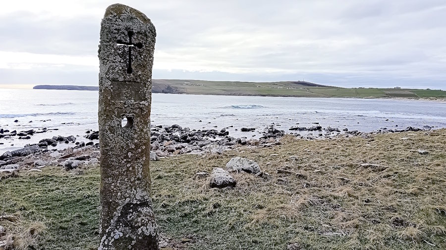
St Peter’s Kirk is normally open for viewing from 11 a.m. to 3 p.m. (Thursday to Sunday over the summer). There are also regular guided tours of the Kirk and graveyard when it is open. It is just under 4 kilometres (2.4 miles) from St Margaret’s Hope. There is a requestable bus service on Fridays and Saturdays. [Click for details]
Sheena Graham-George
The Burwick, Kirkhouse, and St Margaret’s Hope Listening Walks (and their associated maps) featured on these pages were developed from two grants awarded to local artist Sheena Graham-George by the Culture Collective Fund to bring communities together after Covid. She worked with different folks in the community. The result is a fascinating collage of local life. You can view other elements of Sheena’s work via her website: https://www.sheenagrahamgeorge.com/.
Thanks are also due to Allan Lamont, whose considerable knowledge of St Peter’s Kirk and Eastside and notes on the Kirk have been a great help to what follows.
Introducing St Peter’s Kirk
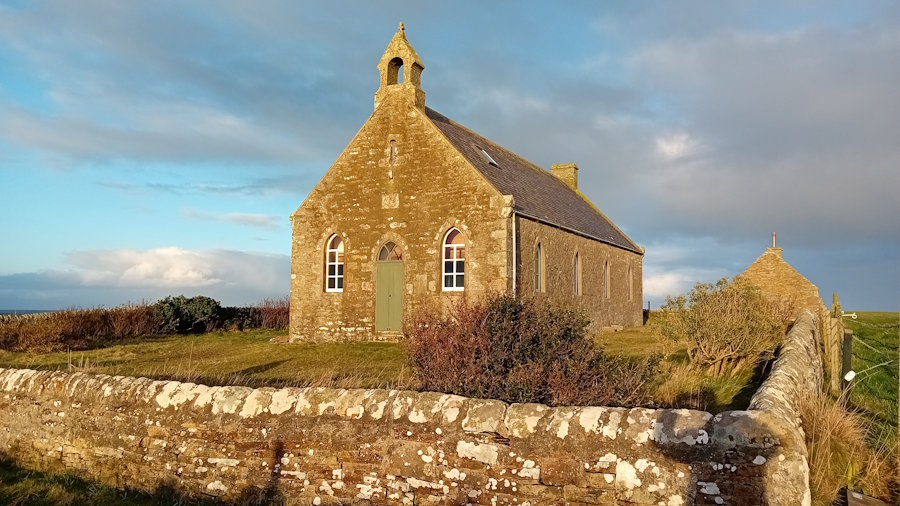
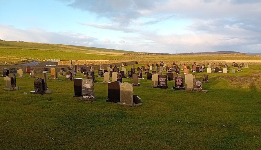
Like St Mary’s in Burwick, St Peter’s is no longer used as a parish church, although occasional marriages and other services do take place in the Kirk. It was the North Parish Church, but it is now owned by Historic Churches Scotland and run by a local charity, The Friends of St Peter’s. The graveyard has recently been expanded to continue serving the north of the island.
The Kirk is a Grade A listed building. As British Listed Buildings notes:
The early 19th century interior is a rare survival and is remarkably complete. The communion tables running lengthwise down the centre of the church and the central box pew for the church elders are particularly worthy of note, and very few examples of either of these features now survive in Scottish churches.
This design features a pulpit with a sounding board on the long wall and two central communion tables that extend a considerable distance. British Listed Buildings also records that the pews are thought to be made from driftwood. In fact, it appears they were made from wood salvaged from a boat that was wrecked close by, the SS Adele, in 1912. When walking around the Kirk, you will see lots of discolouration in the wood, where, as the Friend’s leaflet on the Kirk points out, the nail holes have rusted.
The current Kirk was built in the 17th century (there is a date stone of 1642 over the door on the south east side) and renovated in 1801 (and in 1967). It was likely constructed on the site of an older Eastside church. The door in question is not for members of the congregation, but was the priest’s entrance to the pulpit. There was a similar arrangement at St Mary’s in Burwick, but there, the pulpit and other items were located at the west end of the building.
Like several churches in Orkney, St Peter’s Kirk has a simple rectangular shape surrounded by a graveyard. It also follows St Mary’s with windows facing the sea and plain stone facing the land. Various reasons are put forward for this. One is that it is better in terms of light (with the sun rising in the east), and another is the significance of the sea in the lives of local people. A third possibility is that the windows look to where the founders arrived on the island. For Burwick in the South Parish, the arrival of missionaries from Iona in 580 AD was a significant moment. For St Peter’s Kirk, it was the landing of Christian Picts, possibly a little later, and possibly from Caithness (see the section on the Picts in our ‘brief history‘).
The internal design of the Kirk, with its central communion pew running nearly the length of the building, and pulpit at the centre of the longest wall, is not often found in Scotland. Other elements, such as the vestry and porch, appear to have been added in the nineteenth century. The church hall (now a private property) was a mile (1.7k km) away on the road to and from St Margaret’s Hope (click for map).
The Kirk Hall (built in 1894 but now a private property) was a mile (1.7 km) away on the road to and from St Margaret’s Hope (click for map).
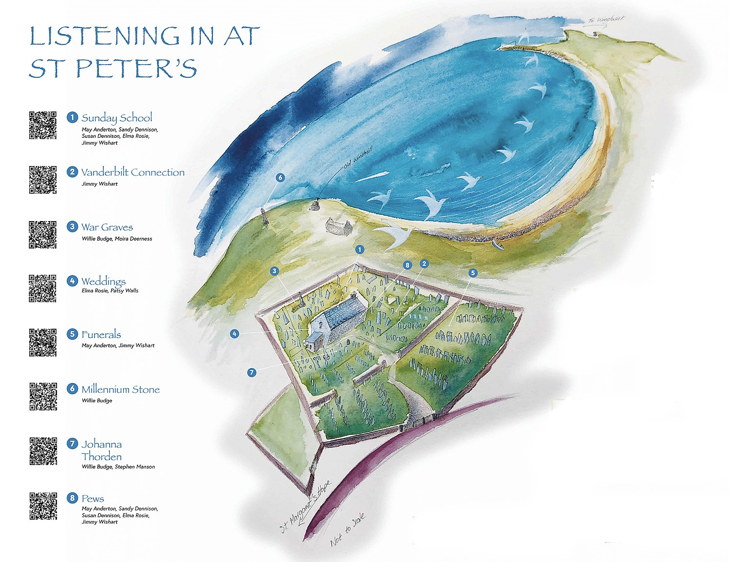
The Listening Walk
There are eight stops on this listening walk.
To hear what the contributors have to say, click the play button [a small triangle pointing right] on the left of your chosen item. If the Kirk is open, you can also find a larger version of the map in the foyer, which enables you to use your mobile device to read the QR code.
1. Sunday School
May Anderson, Sandy Dennison, Susan Dennison, Elma Rosie and Jimmy Wishart
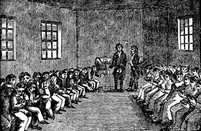
Robert Raikes (1735-1811) is traditionally credited as the pioneer of Sunday Schools. He started his first school (for the children of chimney sweeps) in Sooty Alley, Gloucester (opposite the city prison) in 1780. However, teaching Bible reading and basic skills on a Sunday was known before this. What Raikes achieved was to organise and present Sunday Schooling in ways that caught people’s attention.
Sunday schools are believed to have started spreading in Scotland in 1787. The Scots Magazine reports schools opening in Aberdeen and Glasgow. They had two basic functions. To:
- provide study opportunities for children who received no schooling during the rest of the week (mostly because they were working); and
- reduce what was seen as ‘lawlessness and Sabbath profanation’.
Many schools were affiliated with evangelical groups and churches, and emphasised Bible study. They were viewed with suspicion by the Church of Scotland. The creation of the Free Church and the United Presbyterian Church in the 1840s created a rapid growth in the number of children and young people attending. Numbers increased across Scotland into the 1890s, then a decline set in and has continued to the present day.
The contributors to the Listening Walk provide an engaging picture of what ‘attending’ Sunday School involved for them.
Many had to walk to the Kirk or catch the special Sunday Bus that travelled around the parish. The bus covered Grimness to the north, St Margaret’s Hope and Hoxa to the west, and Herston to the south-west. Sunday School attenders had to go to the Kirk, stay for the first 10 minutes of the service, and then get the bus to where schooling was taking place. This was either in St Margaret’s Church in St Margaret’s Hope or the old Church Hall pictured above (it was up the hill on the north side of Haybrake Road – click for map). As we hear from the contributors, this arrangement also opened up alternative activities, including ‘bunking off’.
We also hear stories about avoiding the Sunday School ‘uniform’, and rewards for attenders (toffee), for keeping your attendance book up to date, and having to walk to and from the Kirk.
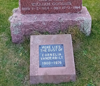
2. The Vanderbilt Connection
Jimmy Wishart
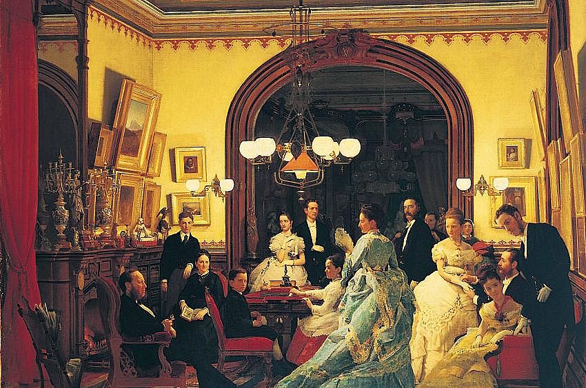
The Vanderbilts were once the wealthiest family in the United States. They began by developing shipping and railroad empires, and then branched out into various other activities. A graveyard by the North Sea seems a long way from the family portrayed by Seymour Joseph Guy above. Yet, our second stop on the Listening Walk is a plaque which reveals that a container of the ‘dust’ of Cornelia Vanderbilt (1900-1976) is buried beneath the stone in front of us. Cornelia Stuyvesant Vanderbilt was the 4th generation, great-granddaughter of Cornelius Vanderbilt, the founding father of the above empires. The final name on the gravestone, William Goodsir (1928-1984), is why the plaque was placed here.
Cornelia had been born at the Biltmore Estate in North Carolina. Her childhood was spent there in a 250-room mansion (the largest privately owned home in the USA). The house and her father’s fortune passed to her after her father’s death. She went on to marry a British aristocrat (Hon. John Francis Amherst Cecil) in 1924 and then divorced him in 1934. She had moved to Paris, dyed her hair bright pink, changed her name to Nilcha (and later to Mary), and never returned to the USA. She then moved to London and married again in 1949. Her husband was Captain Vivian Francis Bulkeley-Johnson, who had served in the Air Ministry. He died in 1968.
 When eating in a London restaurant, she was served by William Robert “Billy” Goodsir, and she fell in love with him. He had been a model and actor. They were married in 1972. He was 26 years her junior – and they were only able to spend three years together before she died. They lived at her home, The Mount (a farm close to the village of Churchill in Oxfordshire), but visited South Ronaldsay to spend time with Billy’s mother, Catherine (aka Kitty). Cornelia died in 1976. Her ashes were placed at a church near her home with the request that they be buried with William. He died in 1984, and his mother, Catherine, followed a few months later.
Jimmy Wishart describes Catherine as a ‘particular character’ and talks about visits from Billy to see her. On at least one of these trips, he was accompanied by Mary (Cornelia).
3. War Graves
Willie Budge and Moira Deerness
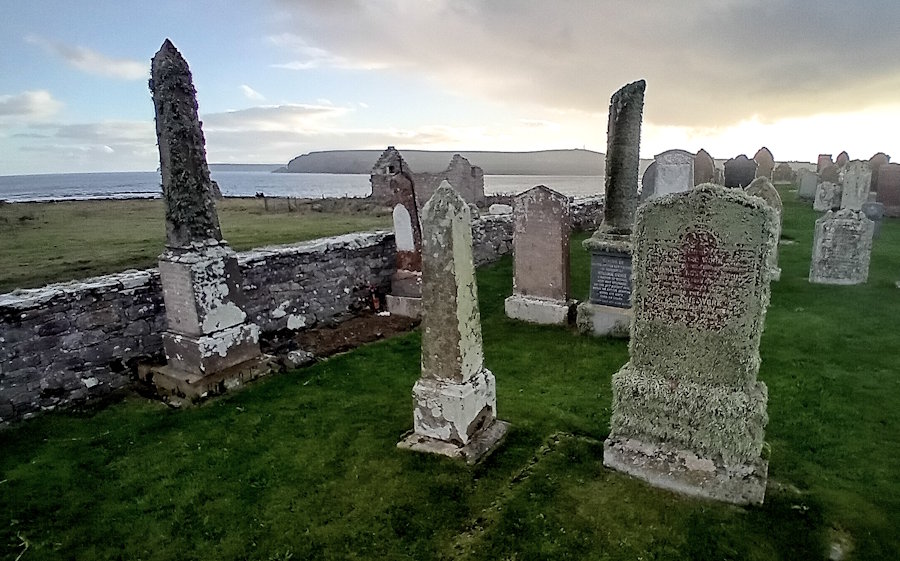
As can be seen from the opening map, these war graves are next to the graveyard wall and not far from the Kirk’s lobby. They date from the First and Second World Wars. Moira Deerness focuses on the death of a 17-year-old boy, whom we believe to be Alexander Brown, a deckhand on HMS Imperieuse. He belonged to the Mercantile Marine Reserve and died in 1918.
Willy Budge talks about the loss of two men operating an anti-aircraft gun in 1940: Thomas Cockburn and Alfred Sayers, Royal Artillery. They were working on one of the four guns on Herston Hill (click for map). A shell jammed in the barrel, and the breech blew out, killing the two men.
Other graves include those of:
Gunner Ernest Henry Rogers from H.M.S. “Cyclops II.” (Royal Marine Artillery), who died at Hoxa Battery on May 16, 1916.
Private L. J. Robertshaw, Royal Marine Light Infantry, also from H.M.S. “Cyclops II”, who died October 21, 1916.
Private Robert Henderson, Seaforth Highlanders, who died aged 20 in 1918.
Gunner John Court, Royal Marine Artillery, who died aged 34 in 1914.
There are also several graves dotted about the graveyard that are not included in some of the online listings:
William Dass, killed in action aged 20, February 22, 1917.
Archie Sinclair, killed in France aged 24, October 1, 1918
4. Weddings
Elma Rosie and Patsie Walls
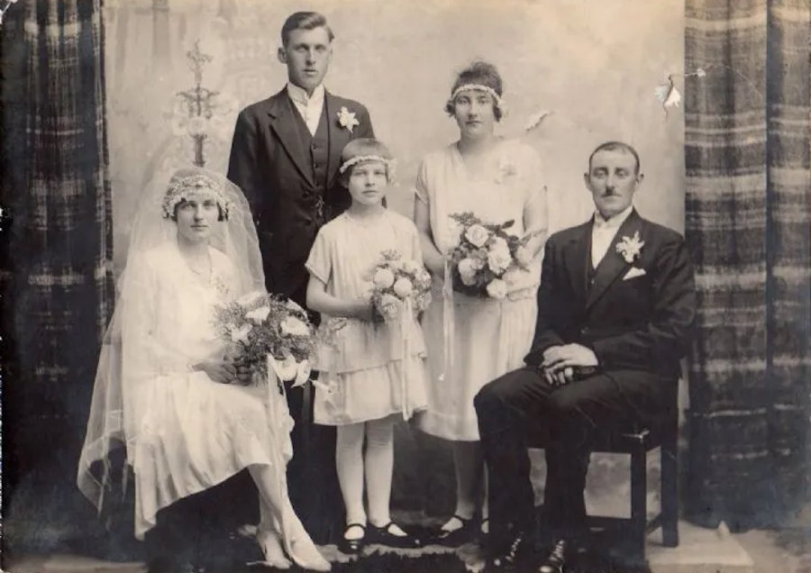
Several interesting points arise from what Elma Rosie and Patsie Walls have to say (Patsie is Elma’s daughter). First, weddings often took place after 7 pm on a Friday. Second, they could take place in the Manse rather than the Kirk. (The Manse is to the north of the Kirk and can be seen some distance away. It overlooks Manse Bay – click for a map). Third, and not unexpectedly, there could be problems with the weather. The position of the Kirk could mean it is very breezy, but there might also be issues with rain (it is quite a distance from the gate to the Kirk). Last, but not least, the design means that there is no way to walk side by side to the altar. As one of the contributors put it, one person has to park in the aisle. You also have to walk around the pillars when entering or leaving the Kirk.
5. Funerals
May Anderton and Jimmy Wishart
May Anderton begins with her grandmother’s memories of funerals at a time when women did not attend them but stood outside and watched as the coffin procession went past. Born in 1936, she described an early procession south to the Kirk from Mires Cottage (aka Myres), not far from Honeysgeo, Grim Ness [click for map]. The men took turns carrying the coffin along the coast to St. Peter’s – a distance of around 3 kilometres or 1.9 miles.
Jimmy Wishart begins by describing his family’s move, when he was five, from the South Parish to Knockhall, a farm close to St Margaret’s Hope. His father gradually acquired land, which included Wheems, a farm with land adjacent to Kirkhouse Road, and that continued past the Kirk to the sea. When he died, he was buried in the Kirk graveyard/cemetery. Orkney Islands Council had acquired some of the land next to the Kirk from his father to extend the cemetery. The result was that his grave was in what had been his own land. After the funeral, one of his grandchildren played the bagpipes. This appears to have attracted what had been his cattle down the Brae to the cemetery fence.
6. Millennium stone
Willie Budge
Created by Willie Budge, a local craftsman and contributor to the Listening Walk, this wonderful stone features various historical elements, including a dragon head, Pictish symbols, and a Viking longship. It also cleverly uses a hole that echoes that of The Stone of Odin at the Ness of Brodgar (click to read about the different interpretations of why the ‘Odin’ hole was created). The stone is just beyond the graveyard. To reach it, you need to take the pathway from the right of the car park and follow the track past the old fishing station and store, and the former windmill. By the mill, you can see the remains of what appears to be a wharf and what trove.scot describes as a series of 6 kelp burning pits with associated debris. [click for map] [for more about the importance of kelp for the islands, see A brief history of South Ronaldsay
Willie describes how he approached the task of carving the stone and the thinking behind the different elements of the design. For example, he cut through the cross and the hole and positioned the stone to look south. It means that light can fill them throughout the day. Carvings reflect the periods covered – Pictish, Norse and present-day Christian. For example, he makes links to the Pictish carvings that were part of the Kirk (but are now exhibited in the National Museum of Scotland). He also used his own feet and hands to model other aspects of the Stone, and jokes that you can see the impact of fashion in the 1960s on his feet (he wore Winkle Pickers).
7. Johanna Thorden
Willie Budge and Stephen Manson
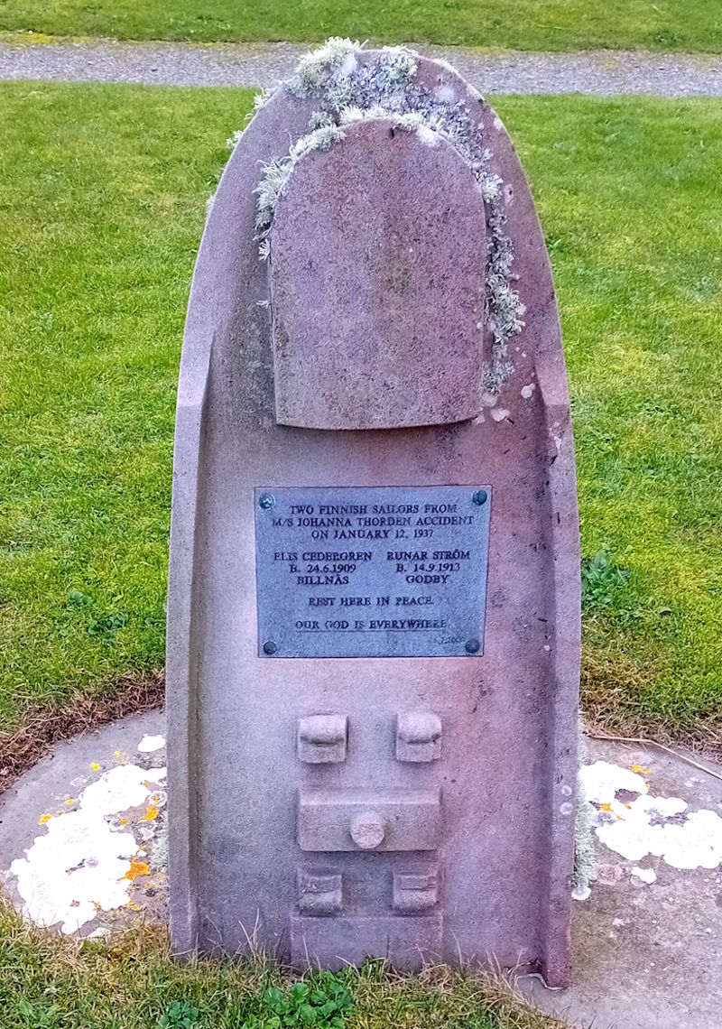
The Finnish cargo ship Johanna Thorden had run aground – and quickly broke apart – at the Clett of Stroma in the Pentland Firth on January 12, 1937. The boat was new (launched in September 1936) and named after the mother of the Swedish shipping company’s owner. At the time the ship was driven ashore, it was carrying a mixed cargo from New York and was en route to Gothenburg. It was said to have had a crew of 20 plus 18 women and children. Thirty lives were lost (26 crew members, 2 children and 2 women). [Click for details of the shipwreck].
Most of the bodies were returned to the countries of origin, but two bodies were discovered later and buried in an unmarked grave in the Kirk graveyard (see below)
 Willie Budge and Stephen Manson discuss some of the key events and factors that contributed to the loss of the ship.
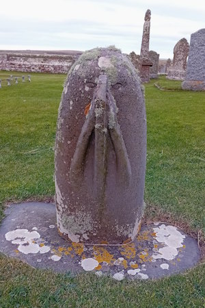
Towards the end of their discussion of the events, Willie Budge talks about some of the elements of the grave stone he created to commemorate the deaths of Elis Cedergren (b. 24.6.1909) and Runar Ström (b. 14.9.1913).
He also discusses the rear of the Stone, where he had used the image of two hands to represent the propellers that had steered the ship to its doom and had used a representation of its fin as a nose. It creates an unusual and rather moving grave stone.
8. Pews
May Anderson, Sandy Dennison, Susan Dennison, Elma Rosie and Jimmy Wishart
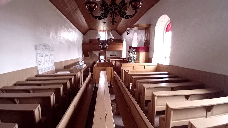
Around 1770/80, the capacity of the Kirk was said to be 414 (based on a calculation that allowed 18 inches per person). By the 1790s, it was clear that the Kirk would need a lot of work, and this was confirmed by the loss of the roof in 1793. The current Kirk building was opened in 1801, and through the efforts of local people in the early 1980s, lofts were added to hold another 250 people. The bell tower above the balcony at the north end of the Kirk was out of use for many years and occupied by birds (from around the mid-1960s to 2022). According to the notes on the Kirk, the bell is marked with the date 1771 and the words, The Hope.
As we hear from the contributors to the Pews discussion, people and families often sat in the same rows each Sunday. As we have already seen, the current pews date back to just after 1912 and are not very comfortable. The harmonium in the centre of the Kirk also dates from around this time.
If you have time to spare, the walk south along the beach is fascinating, and towards the north are various significant landmarks such as Kirk Ness Dyke and Kirk Ness Mound. These are a short walk north from the Millennium Stone. The dyke is within a planticrub – which is defined by Canmore as a ‘small square, circular or rectangular enclosure used for growing root crops, usually without an entrance’ (click for map). The mound is up behind the planticrub and is described in Canmore as an ‘amorphous, turf-covered, stony knoll… locally believed to cover an ancient structure.
If you carry on along the coast to the north, you can see what remains of the Irene – which sank on March 17, 1969. It had been on its way to Norway and was struggling to deal with the Force 10 gale. As a result, she ran out of fuel, had taken on a lot of water, and was drifting towards South Ronaldsay. She went aground here, and all of the crew of eleven were winched off the boat. However, one of the two lifeboats sent out to rescue them (the Longhope lifeboat) appears to have capsized with the loss of all eight crew members. The Irene gradually disintegrated, leaving her boilers, engine and various other elements.
___
Further reading
There are various books about Orkney as a whole, but only a few that focus on Burray and South Ronaldsay. Here are three to start with:
Picken, S. D. B. (1972). The Soul of an Orkney Parish. Kirkwall: The Kirkwall Press. https://archive.org/details/souloforkneypari0000stua.
Struthers, J. M. (2013). Broch Island. A history of the island of Burray in Orkney. Published by J. M. Struthers via lulu.com.
Watson, The Revd Mr. James. (1795). United Parishes of South Ronaldsay and Burray. Statistical Accounts of Scotland – OSA Vol XV: https://stataccscot.ed.ac.uk/static/statacc/dist/viewer/osa-vol15-Parish_record_for_Ronaldshay_and_Burray_in_the_county_of_Orkney_in_volume_15_of_account_1/
One further excellent study of Orkney that uses quite a bit of material from the two islands is:
Marshall, Peter. (2024). Storm’s Edge. Life, death and magic in the Islands of Orkney. London: William Collins.
If you enjoyed this listening walk why not try the sister walks in St Margaret’s Hope and St Mary’s Kirk, Burwick.
© The opening image is by Sheena Graham-George.
If you find any mistakes in this piece or think something needs adding, please let us know.
All photographs without acknowledgement: mks | CC BY-NC-SA licence.
Referencing the listening walk: Sheena Graham-George and contributors to The Listening Walk [with additional material from Allan Lamont and Mark K Smith] (2025). Exploring Kirkhouse and the St Peter’s Kirk Listening Walk, Exploring South Ronaldsay. St Margaret’s Hope. [https://exploringsouthronaldsay.net/exploring-and-visiting-kirkhouse-and-st-peters-kirk/]. Retrieved: insert date].
© Sheena Graham George and Exploring South Ronaldsay 2025
Standing Stones
Visit our section on Standing Stones for further information
Walking South
See our walking page for details of the South Coast walk or click here.
updated: January 28, 2026